tweetindex
ES

NWS Storm Prediction Center

@NWSSPC · Norman, OK, USA · joined 21 May 2012

Official X account for the National Weather Service Storm Prediction Center. Details: https://t.co/iLNLwbR2yI

543 640Followers
163Following
141 981Posts total
676.5KViews on collected posts

Últimas publicaciones

5:49pm CDT #SPC_MD 2289 , #kswx #okwx, https://t.co/BTzM9EVBdR https://t.co/Kqv6wBXRUq
8K views · 19 likes · 6 reposts · 0 replies Open on X →
4:57pm CDT #SPC_MD 2288 , #arwx #txwx #okwx, https://t.co/FafwCqfJDi https://t.co/lklkVpQfu1
9.7K views · 13 likes · 7 reposts · 0 replies Open on X →
2026-09-12 21:42Z #SPC Day3-8 #FireWX Outlook https://t.co/xfgNy4UEyt 8.4K views · 4 likes · 1 reposts · 0 replies Open on X →
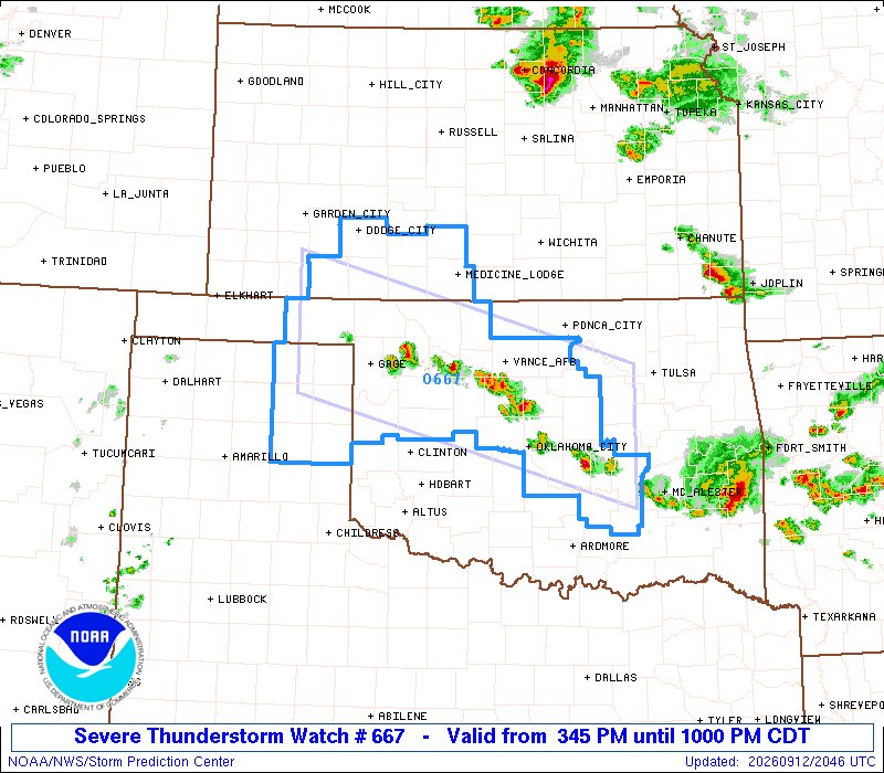
3:47pm CDT #SPC_Watch WW 667 SEVERE TSTM KS OK TX 122045Z - 130300Z, #kswx #okwx #txwx, https://t.co/TxC5JicGKa https://t.co/nndpNNGIIn
9.1K views · 25 likes · 11 reposts · 0 replies Open on X →
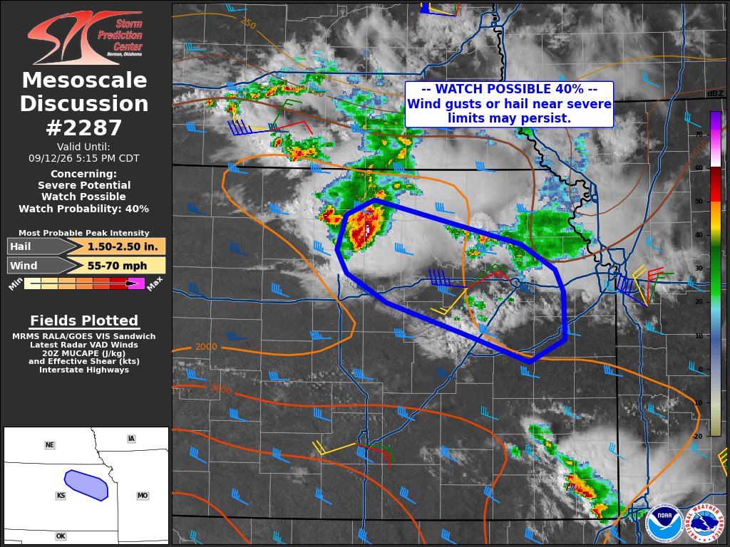
3:46pm CDT #SPC_MD 2287 , #kswx, https://t.co/lQ3zZFDmue https://t.co/PK1pF4aOXj
8.9K views · 18 likes · 7 reposts · 0 replies Open on X →
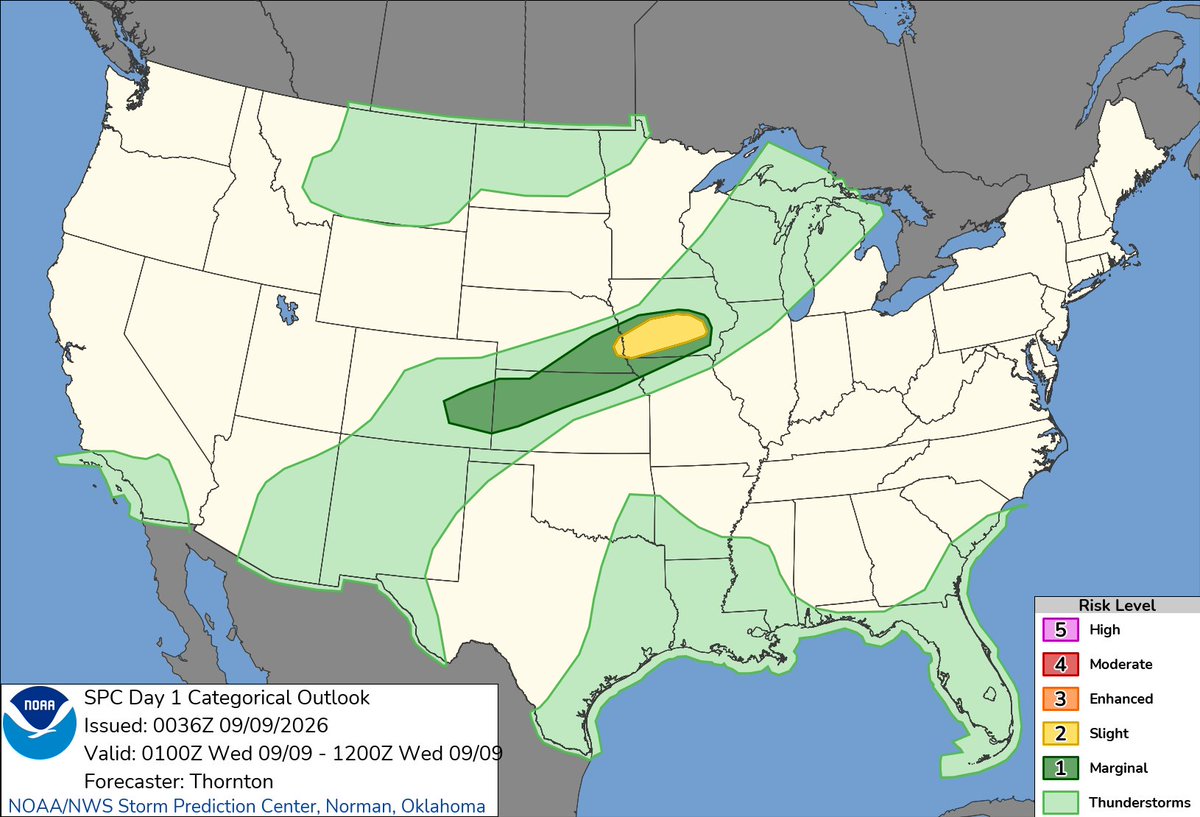
#SPC Sep 9, 2026 0100Z Thunderstorm Outlook https://t.co/AeK0ArQF0G 8.9K views · 10 likes · 0 reposts · 0 replies Open on X →
7:38pm CDT #SPC Day1 Outlook Slight Risk: THIS EVENING ACROSS PORTIONS OF IOWA https://t.co/TgJgC6cj9Y https://t.co/Uox5Sn1c8h
9.8K views · 45 likes · 11 reposts · 1 replies Open on X →
7:35pm CDT #SPC_MD 2272 , #ilwx #iawx, https://t.co/sXHNFkULlR https://t.co/PfMyM9IUtw
9.2K views · 22 likes · 7 reposts · 0 replies Open on X →
2026-09-08 22:00Z #SPC Day3-8 #FireWX Outlook https://t.co/xfgNy4UEyt 9.3K views · 8 likes · 1 reposts · 0 replies Open on X →
@NWSSPC Stay safe Minnesota 39 views · 1 likes · 1 reposts · 0 replies Open on X →
@NWSSPC NORTHWEST INDIANA..NOT A TORNADO? https://t.co/pVhJQDlUwA
3.2K views · 12 likes · 1 reposts · 4 replies Open on X →
@NWSSPC Reilly Dibble can run faster than that wind gust 3K views · 9 likes · 0 reposts · 0 replies Open on X →
@NWSSPC @MaxVelocityWX 2.1K views · 5 likes · 0 reposts · 0 replies Open on X →
The damaging wind swath from Wednesday, June 10 has been preliminarily confirmed as a derecho. The wind swath had a track length over 400 miles with a footprint just under 100,000 square miles. The strongest known gust was measured at over 94 mph. https://t.co/OR9BnrDKYh
222.8K views · 1.4K likes · 317 reposts · 14 replies Open on X →
@NWSSPC M kvchy f led n Brddeder ccc 508 views · 0 likes · 0 reposts · 0 replies Open on X →
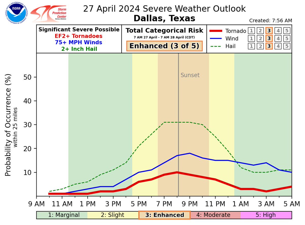
D. Timing Graphic showing severe storm information for the Dallas/Fort Worth Metro and areas in North Texas. https://t.co/wSPWMjzBDp
30.5K views · 105 likes · 37 reposts · 1 replies Open on X →
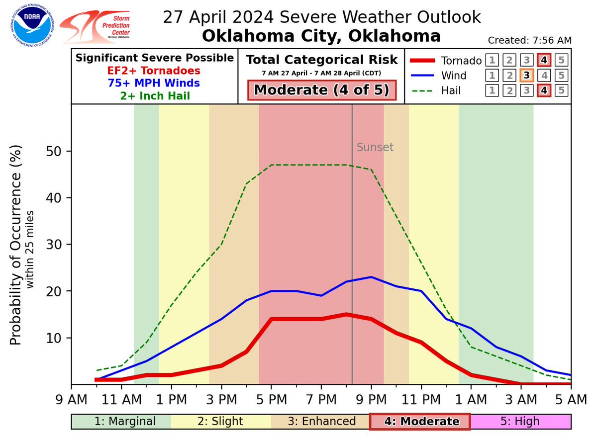
C. Timing Graphic showing severe storm information for Oklahoma City and areas in western/central Oklahoma. https://t.co/nlIVk3yJb9
34.7K views · 146 likes · 42 reposts · 3 replies Open on X →
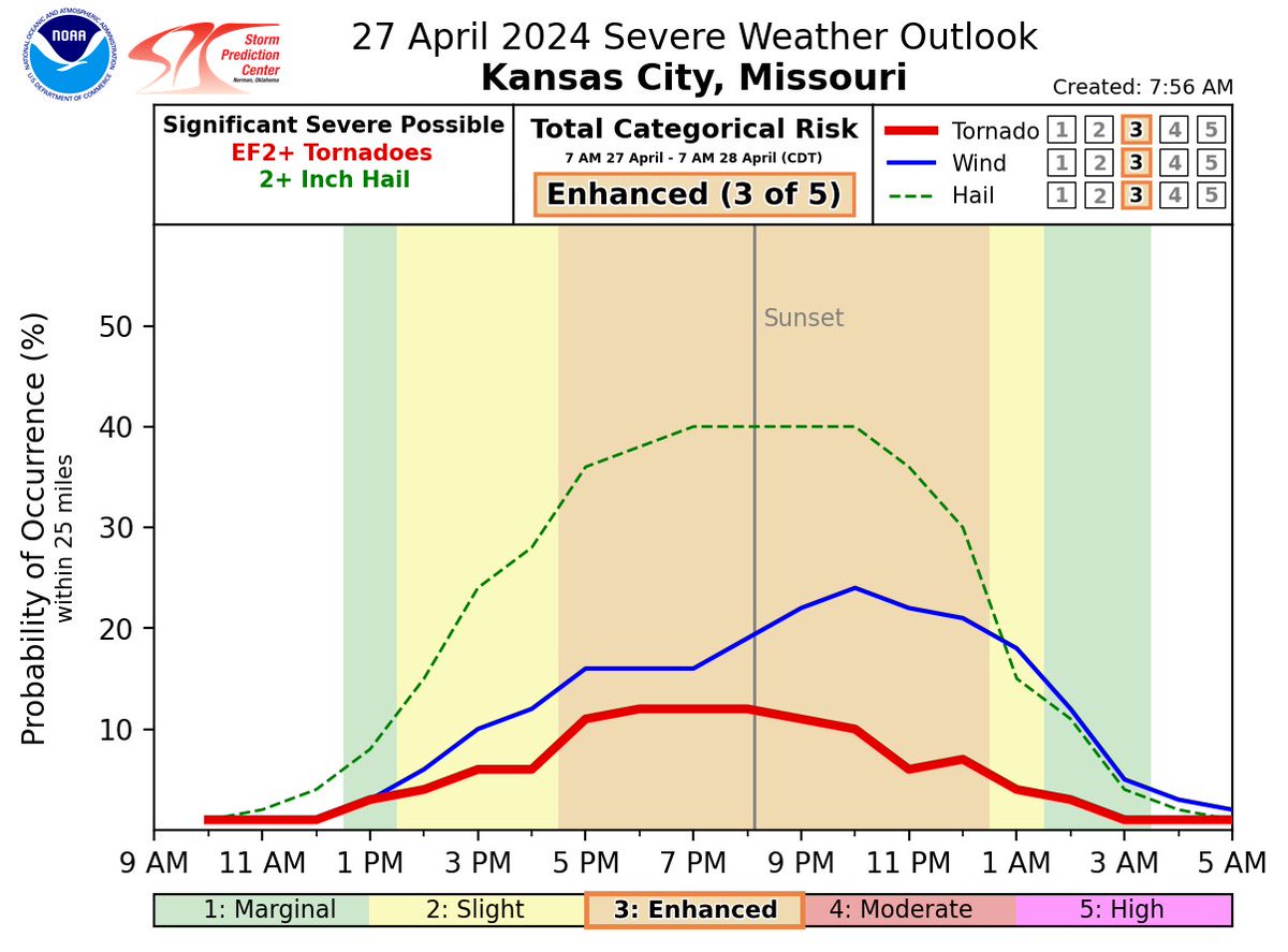
B. Timing Graphic showing severe storm information for The Kansas City area in eastern Kansas and western Missouri. https://t.co/YzjGqm7eBj
11.2K views · 44 likes · 13 reposts · 2 replies Open on X →
A. Timing Graphic showing severe storm information for Salina to Wichita and areas in northern/central Kansas. https://t.co/ctDXA6poQi
11.9K views · 41 likes · 11 reposts · 1 replies Open on X →
Here is a break down of timing for select areas of the country for the severe storms today and tonight. Multiple rounds of severe thunderstorms are possible across several areas. Please see the individual graphics below for more specific timing information. https://t.co/QoQqCmmcI
28.8K views · 161 likes · 52 reposts · 7 replies Open on X →
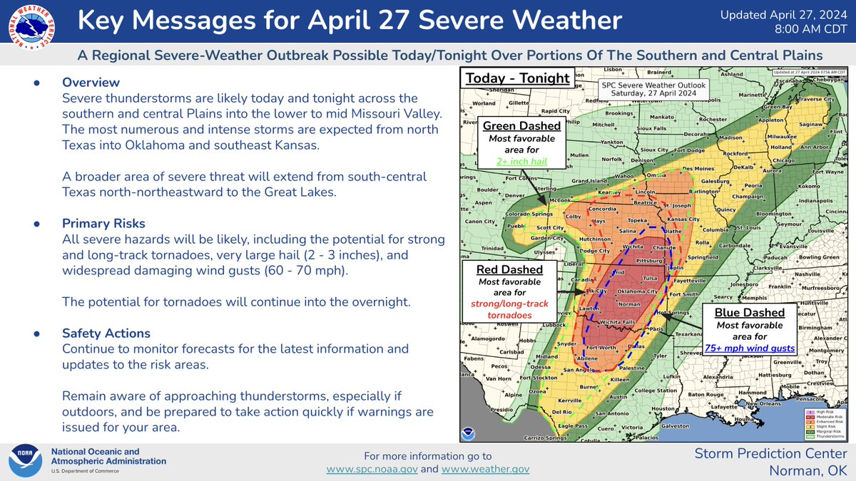
Severe storms are most likely after 11 am. Tornadoes and strong thunderstorms will remain possible through the overnight. Have multiple ways to receive updated weather information. See your local NWS office at https://t.co/6ByLpjGeLV or visit https://t.co/QMmU4tCxt1 for info. 24.1K views · 52 likes · 13 reposts · 1 replies Open on X →
⚠️Sat 4/27/24 A Regional Severe Weather Outbreak is possible over the Plains and mid MS Valley today/tonight. Numerous severe thunderstorms are possible over parts of OK, KS and North TX . Strong, long-track tornadoes, very large hail, and damaging winds are likely https://t.
222.3K views · 1K likes · 387 reposts · 11 replies Open on X →

Frente a cuentas del mismo tamaño

10 publicaciones de los últimos 90 días, junto al rango de 100K–1M seguidores. alcance normal para su tamaño, reacción más débil que la mayoría.

Visualizaciones medianas8 992esta cuenta5 983mediana de 100K–1M
Alcance, %1.65%esta cuenta1.49%mediana de 100K–1M
Interacción, %0.30%esta cuenta0.93%mediana de 100K–1M
MétricaEsta cuentaMediana de 100K–1MProporción
Visualizaciones medianas por publicación8 9925 9831.50×
Alcance (visualizaciones ÷ seguidores)1.65%1.49%1.11×
Tasa de interacción0.30%0.93%0.32×

Otras cuentas de este rango →   Comparar con otra cuenta →   Cómo se construyen estas referencias →

Growth & engagement

How the posts we collected actually performed: views and reaction rate post by post, what the audience did with them, and where the follower count goes.

Views per post

222.8K12 Jun
2.1K
3K
3.2K
394 Sep
9.3K8 Sep
9.2K9 Sep
9.8K
8.9K
8.9K12 Sep
9.1K
8.4K
9.7K
8K

Last 14 collected posts, oldest on the left. The scale is logarithmic: one post can outrun the rest a hundred times over.

Engagement rate per post

0.77%12 Jun
0.24%
0.30%
0.54%
5.13%4 Sep
0.10%8 Sep
0.31%9 Sep
0.59%
0.11%
0.28%12 Sep
0.40%
0.06%
0.21%
0.31%

Reactions — likes, reposts, replies and quotes — divided by views. Median for 100K–1M accounts is 0.93%.

What the audience does

Likes70.7%3 121 in total
Reposts20.9%925 in total
Replies1.0%45 in total
Quotes2.1%92 in total
Bookmarks5.3%233 in total

Share of every reaction we collected for this account. Replies mean argument, reposts mean endorsement, bookmarks mean the post was worth keeping.

The follower curve appears once this account has two daily snapshots — we take one a day, and this one is on its first.

Cuentas similares