tweetindex
PT

NWS Twin Cities

@NWSTwinCities · Chanhassen, MN · joined 07 Jun 2012

Official X account for the National Weather Service Twin Cities, Minnesota. Details: https://t.co/Ou56XBf7km

120 282Followers
473Following
55 291Posts total
72.8KViews on collected posts

Posts recentes

@NWSTwinCities Gonna be some muddy HS football games this weekend 386 views · 0 likes · 0 reposts · 0 replies Open on X →
@NWSTwinCities So you're saying there's a chance. 411 views · 1 likes · 0 reposts · 0 replies Open on X →
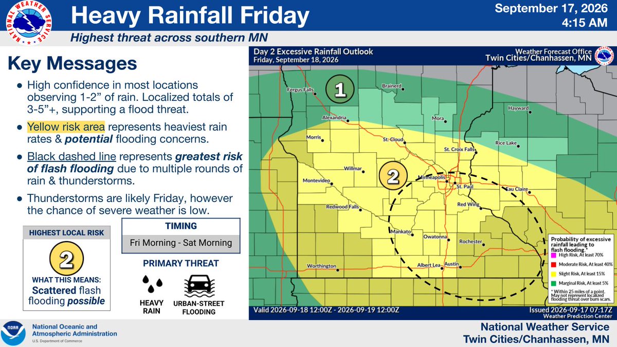
HEAVY RAIN: A weather system will produce a widespread swath of 1-2" rainfall amounts on Friday. A narrow axis of heavier amounts (3-5"+) is likely due to thunderstorms Friday afternoon and evening across southeastern MN/western WI, resulting in an elevated flash flood threat. ht
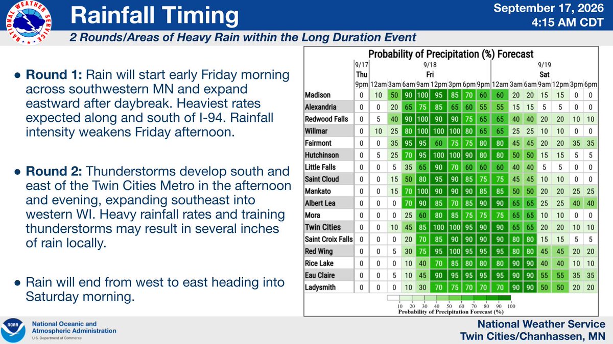
A weather system will produce a widespread swath of heavy rain (1-2") across much of the southern half of Minnesota and western Wisconsin on Friday. Rain is likely for much of the day, however there are "two rounds" of heavy rain expected. The first round begins early Friday across southwestern MN. Rain will overspread the forecast area through the morning and continue into the early afternoon before rainfall rates begin to weaken.

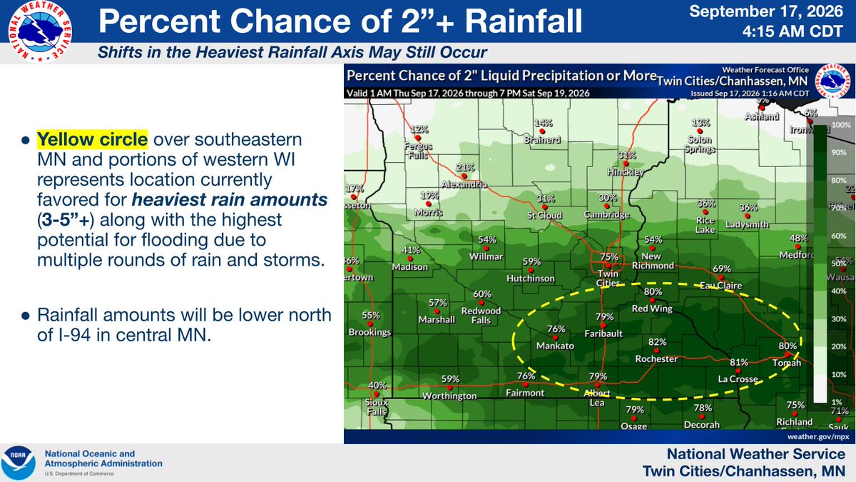
Round two will feature the development of showers and thunderstorms across southeastern MN & portions of western WI Friday afternoon and evening. Heavy rainfall rates and training of thunderstorms will support localized rainfall totals in excess of 3-5"+ and support an elevated flash flood threat. Rain ends from west to east heading into Saturday morning.
Graphic that displays percentage chance of rainfall amounts exceeding 2" for locations across south central MN and western WI.
Graphic that displays hourly precipitation chances Friday into Saturday for many locations across southern Minnesota and western Wisconsin.
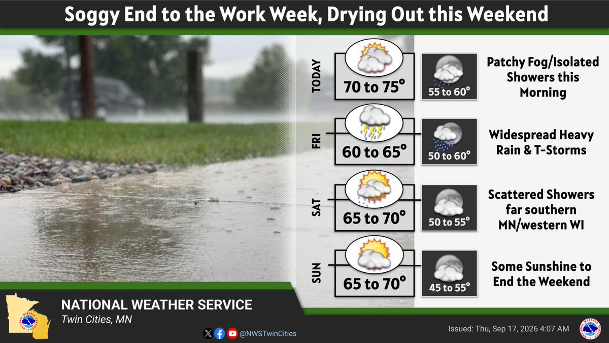
Today: Patchy fog this morning. Mostly cloudy with highs in the mid 70s. 
Friday - Widespread heavy rain and storms. Highs in the low 60s. 
Saturday: Scattered morning showers. Highs in the low 70s. 
Sunday: Partly sunny highs in the upper 60s.
28.2K views · 142 likes · 14 reposts · 2 replies Open on X →
Updated lows 😅 https://t.co/oSpfWNxIk2 2.1K views · 6 likes · 0 reposts · 0 replies Open on X →
Uhhhh do NOT look at those lows 😶 9K views · 48 likes · 2 reposts · 4 replies Open on X →
@NWSTwinCities The Heat index has been pretty bad at the fair I'll tell you that 180 views · 1 likes · 0 reposts · 0 replies Open on X →
It's may be September, but it still feels like July out there #mnwx #wiwx https://t.co/vAJsbIJ0kz 13.9K views · 33 likes · 1 reposts · 4 replies Open on X →
We'll be watching the potential for a wind threat to develop with these storms moving SE across N MN early this morning... we're looking okay right now with things pretty well north, but some additional development is already starting and could shift things more south #mnwx #wiwx 6.5K views · 19 likes · 2 reposts · 1 replies Open on X →
Severe Thunderstorm Warning continues for Clarissa MN, Eagle Bend MN and Miltona MN until 10:00 PM CDT. This storm will contain two inch sized hail! https://t.co/TzgjI9K0x4 6.4K views · 7 likes · 1 reposts · 0 replies Open on X →
Severe Thunderstorm Warning including Clarissa MN, Eagle Bend MN and Miltona MN until 10:00 PM CDT https://t.co/ajN4gyjDX4 5.9K views · 9 likes · 0 reposts · 0 replies Open on X →

Em comparação com contas do mesmo porte

10 posts dos últimos 90 dias, ao lado da faixa de 100K–1M seguidores. aparece para muita gente, mas poucos desses espectadores reagem.

Mediana de visualizações6 124esta conta5 983mediana para 100K–1M
Alcance, %5.09%esta conta1.49%mediana para 100K–1M
Engajamento, %0.30%esta conta0.93%mediana para 100K–1M
MétricaEsta contaMediana para 100K–1MProporção
Mediana de visualizações por post6 1245 9831.02×
Alcance (visualizações ÷ seguidores)5.09%1.49%3.42×
Taxa de engajamento0.30%0.93%0.32×

Outras contas desta faixa →   Comparar com outra conta →   Como estas referências são construídas →

Growth & engagement

How the posts we collected actually performed: views and reaction rate post by post, what the audience did with them, and where the follower count goes.

Views per post

5.9K4 Sep
6.4K
6.5K
13.9K
180
9K
2.1K
28.2K17 Sep
411
386

Last 10 collected posts, oldest on the left. The scale is logarithmic: one post can outrun the rest a hundred times over.

Engagement rate per post

0.15%4 Sep
0.13%
0.34%
0.30%
0.56%
0.60%
0.29%
0.57%17 Sep
0.24%
0.00%

Reactions — likes, reposts, replies and quotes — divided by views. Median for 100K–1M accounts is 0.93%.

What the audience does

Likes86.1%266 in total
Reposts6.5%20 in total
Replies3.6%11 in total
Quotes2.3%7 in total
Bookmarks1.6%5 in total

Share of every reaction we collected for this account. Replies mean argument, reposts mean endorsement, bookmarks mean the post was worth keeping.

The follower curve appears once this account has two daily snapshots — we take one a day, and this one is on its first.

Contas semelhantes

Frequently asked questions about @NWSTwinCities

How many followers does @NWSTwinCities have?

120 282 followers.

How many posts has @NWSTwinCities published?

55 291 posts.

How do posts by @NWSTwinCities perform?

Collected posts: 10. Views: 72 841. Likes: 266.