tweetindex
TR

NWS Austin/San Antonio

@NWSSanAntonio · New Braunfels, Texas · joined 30 May 2012

Official X account for the National Weather Service Austin/San Antonio. Details: https://t.co/c97VpqKERb

85 078Followers
267Following
58 831Posts total
18.8KViews on collected posts

Son gönderiler

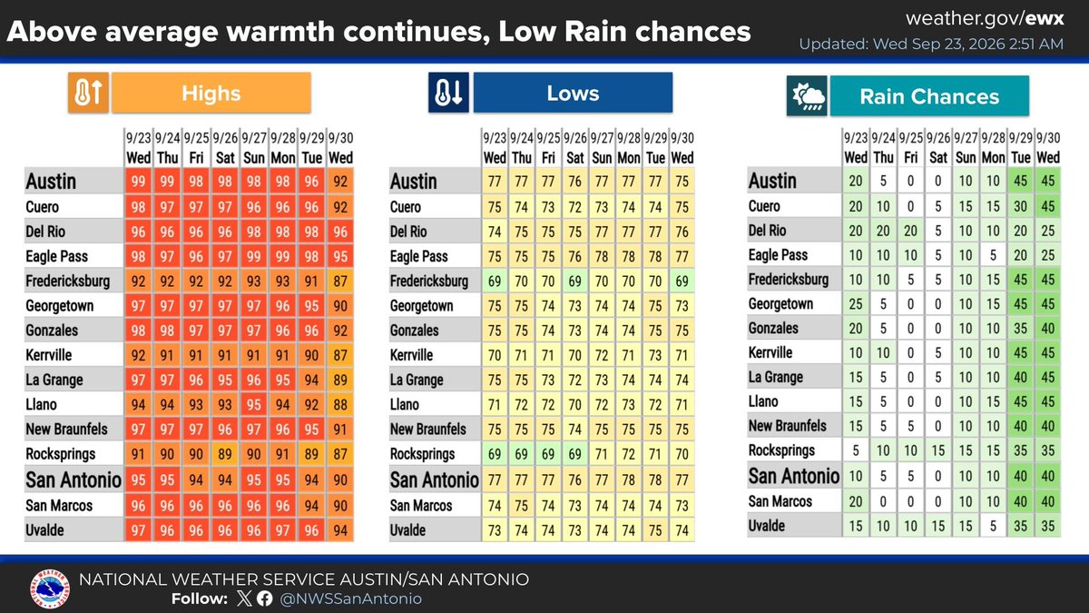
Above average daily temperatures for the next several days with low rain chances. Highs mainly in the 90s with lows in the 70s. #txwx https://t.co/uSwlcaPibX
The graphic shows the highs, lows and chances of rain for the next week. Above average daily temperatures are forecast for the next several days with low rain chances.  Highs mainly in the 90s with lows in the 70s.
1.6K views · 12 likes · 3 reposts · 0 replies Open on X →
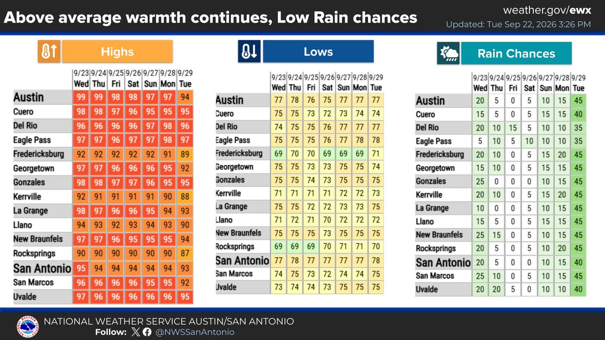
Above average daily temperatures for the next several days with low rain chances. Highs mainly in the 90s with lows in the 70s. #txwx https://t.co/Cz9UfWCnWv
The graphic shows the highs, lows and chances of rain for the next week. Above average daily temperatures are forecast for the next several days with low rain chances.  Highs mainly in the 90s with lows in the 70s.
2.7K views · 9 likes · 0 reposts · 0 replies Open on X →
Isolated showers and storms are possible through early morning along the Rio Grande and on the Southern Edwards Plateau, with partly cloudy conditions elsewhere. Low temperatures in the upper 60s across the Hill Country, with mid to upper 70s elsewhere. Light southeast winds. htt
The graphic shows isolated to scattered showers and thunderstorms along the Rio Grande and parts of the southern Edwards Plateau for this evening. Moon and cloud icons on the right side depict partly cloudy conditions.
2K views · 20 likes · 3 reposts · 0 replies Open on X →
It may be fall, but it's still important to be prepared for high temperatures! ☀️ Visit https://t.co/Q4p88NoiTG to learn heat safety tips, view heat forecasts and outlooks, and learn the signs of heat-related illness. #HeatSafety #txwx https://t.co/JWQTTpRfkT
An illustration showing ways to recognize and treat heat exhaustion and heat stroke. Symptoms of heat exhaustion include dizziness, thirst, heavy sweating, nausea, and weakness. If someone is experiencing heat exhaustion, move them to a cooler area, loosen clothing, sip cool water, and seek medical help if symptoms don't improve. Heat exhaustion can lead to heat stroke. Symptoms of heat stroke include confusion, dizziness, and becoming unconscious. If someone is experiencing heat stroke, call 911, move them to a cooler area, loosen their clothing and remove extra layers, and cool them with water or ice. Heat stroke can cause death or permanent disability if emergency treatment is not given. Stay cool, stay hydrated, and stay informed!
3.4K views · 22 likes · 5 reposts · 0 replies Open on X →
@NWSSanAntonio Make it stop 🥵 please! 26 views · 0 likes · 0 reposts · 0 replies Open on X →
Above-average warmth continues this week across South Central Texas. Expect highs in the 90s to near 100°. Isolated showers and storms are possible today, but rain chances will drop off significantly mid-week before a slight return Sunday. https://t.co/PwXzosLscT
A National Weather Service graphic featuring an aerial daytime photo of downtown San Antonio. The headline reads "Today: Partly Cloudy with a few showers and storms." A sidebar lists Forecast Highs: Coastal Plains 95 to 99 degrees Fahrenheit, I-35 corridor 93 to 99 degrees, Hill Country 91 to 97 degrees, S. Edwards Plateau 90 to 95 degrees, and Rio Grande Plains 98 to 101 degrees. A bottom note states, "Isolated showers and thunderstorms are possible across much of south central Texas." Updated September 21, 2026. Follow @NWSSanAntonio.
A National Weather Service Austin/San Antonio chart titled "Above average warmth continues, Low Rain chances this week" for September 21 to 28. Three tables show Highs, Lows, and Rain Chances across 15 cities including Austin, San Antonio, and Del Rio. Highs remain consistently in the 90s to near 100 degrees. Lows range from the upper 60s to upper 70s. Rain chances peak Monday through Wednesday at 10 to 35 percent, drop to near zero Thursday through Saturday, and return slightly at 5 to 25 percent Sunday and Monday. Provided by weather.gov/ewx.
4.7K views · 29 likes · 7 reposts · 0 replies Open on X →
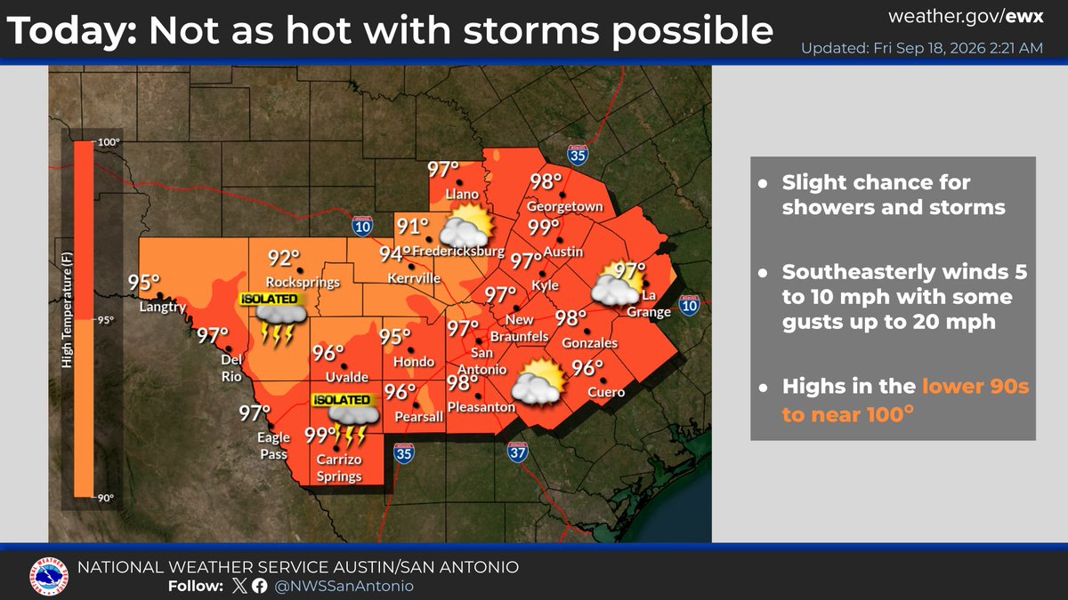
Near-record high temperatures are expected once again today, along with a low chance for showers and storms over the Rio Grande Plains. The forecast calls for more of the same through next week with highs remaining in the 90s. https://t.co/bC2H9arLyd
National Weather Service graphic titled "Unseasonable Warmth Continues with Low Rain Chances" for Sept 18 to Sept 25. It features three color-coded tables for South Central Texas cities, including Austin and San Antonio. The "Highs" table shows daily temperatures persistently in the 90s, occasionally reaching 100 degrees. The "Lows" table indicates warm mornings with temperatures ranging from the upper 60s to upper 70s. The "Rain Chances" table shows low precipitation probabilities throughout the week, ranging from 0 to 35 percent.
National Weather Service graphic titled "Today: Not as hot with storms possible." A map of South Central Texas displays high temperatures ranging from 91 degrees in Rocksprings to 99 degrees in Carrizo Springs and Austin. Isolated thunderstorm icons are placed over western areas like Del Rio and Uvalde, as well as near San Antonio and Fredericksburg. A side panel lists three bullet points: "Slight chance for showers and storms," "Southeasterly winds 5 to 10 mph with some gusts up to 20 mph," and "Highs in the lower 90s to near 100°."
4.3K views · 23 likes · 7 reposts · 0 replies Open on X →

Aynı büyüklükteki hesaplara karşı

Son 90 güne ait 7 gönderi, 10K–100K takipçi aralığıyla yan yana. boyutuna göre olağan erişim, çoğundan daha zayıf tepki.

Medyan görüntülenme2 731bu hesap97210K–100K için medyan
Erişim, %3.21%bu hesap3.80%10K–100K için medyan
Etkileşim, %0.79%bu hesap1.53%10K–100K için medyan
ÖlçütBu hesap10K–100K için medyanOran
Gönderi başına medyan görüntülenme2 7319722.81×
Erişim (görüntülenme ÷ takipçi)3.21%3.80%0.84×
Etkileşim oranı0.79%1.53%0.51×

Bu aralıktaki diğer hesaplar →   Başka bir hesapla karşılaştır →   Bu kıyas değerleri nasıl kuruluyor →

Growth & engagement

How the posts we collected actually performed: views and reaction rate post by post, what the audience did with them, and where the follower count goes.

Views per post

4.3K18 Sep
4.7K21 Sep
2622 Sep
3.4K
2K
2.7K23 Sep
1.6K

Last 7 collected posts, oldest on the left. The scale is logarithmic: one post can outrun the rest a hundred times over.

Engagement rate per post

0.73%18 Sep
0.79%21 Sep
0.00%22 Sep
0.79%
1.14%
0.33%23 Sep
0.91%

Reactions — likes, reposts, replies and quotes — divided by views. Median for 10K–100K accounts is 1.53%.

What the audience does

Likes80.4%115 in total
Reposts17.5%25 in total
Quotes1.4%2 in total
Bookmarks0.7%1 in total

Share of every reaction we collected for this account. Replies mean argument, reposts mean endorsement, bookmarks mean the post was worth keeping.

The follower curve appears once this account has two daily snapshots — we take one a day, and this one is on its first.

Benzer hesaplar