tweetindex
EN

NWS Boulder

@NWSBoulder · Boulder Colorado · joined 03 Jun 2012

Official Twitter account for the National Weather Service Denver/Boulder forecast office. Details: https://t.co/A4aVgbxmgI

146 045Followers
232Following
47 810Posts total
23.5KViews on collected posts

Latest posts

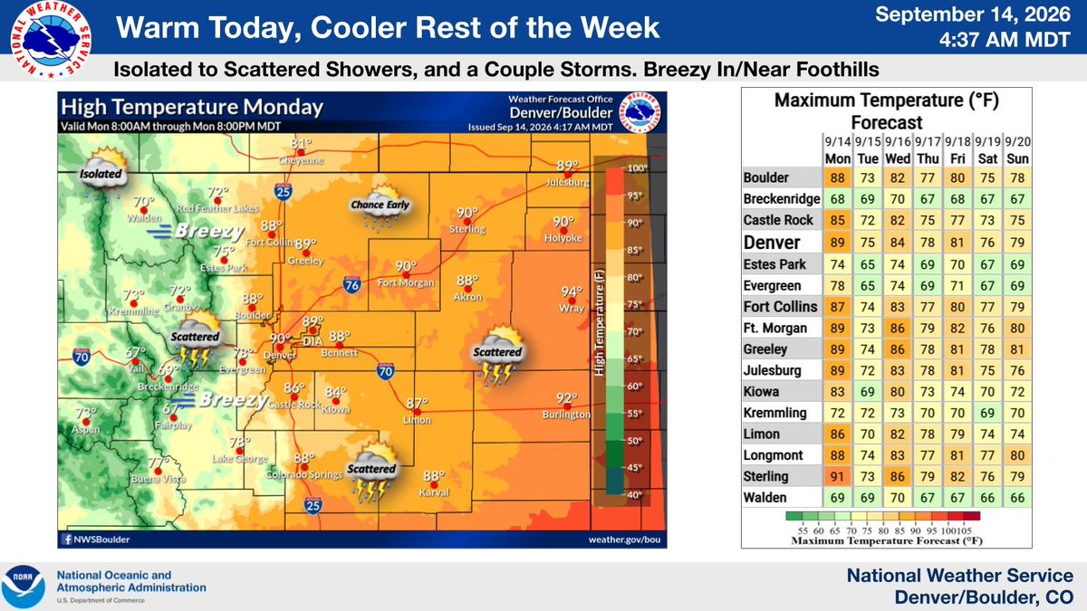
Warm again today, but a few showers and isolated storms around (this morning, and then again late afternoon thru tonight). Cooler Tuesday! Then temperatures closer to normal thru next weekend. Chance of showers and storms most days this week, greatest coverage Thursday. #COwx
Graphic on the left shows forecast high temperatures today, with upper 80s/near 90F degree readings on the plains and I-25 Corridor, 70s to lower 80s in the foothills, and 60s and 70s mountains. Table on the right shows forecast maximum temperatures for selected cities across northeast and north central Colorado through next weekend.
3.9K views · 31 likes · 4 reposts · 0 replies Open on X →
Temperatures tomorrow will be above average before a cold front moves through early Tuesday morning bringing our true first taste of fall. 🍂🍁 Wednesday we should warm up once again to above average temperatures. #cowx https://t.co/34tRjK4p4l
Graphic shows a 3 day extended outlook for Monday through Wednesday. Monday will feature above normal temperatures before a cold front moves through early Tuesday bringing our first taste of fall. Wednesday will rise back up to above average temperatures. Each day will feature the chances for isolated to scattered showers/storms, but not everyone will see rain.
4.6K views · 22 likes · 1 reposts · 0 replies Open on X →
A special weather statement has been issued for Tarryall CO and Bailey CO until 9:00 PM MDT #COwx https://t.co/Tmcb2lke4N
This graphic displays a special weather statement plotted on a map. The statement is in effect until 9:00 PM MDT.  The statement includes Tarryall CO and  Bailey CO.  A STRONG THUNDERSTORM WILL IMPACT NORTHEASTERN PARK and SOUTHWESTERN JEFFERSON AND WESTERN DOUGLAS COUNTIES UNTIL 9 PM MDT. The threats associated with this storm are wind gusts up to 50 MPH and half inch sized hail. Seek shelter in a sturdy structure until the storm passes.
4.5K views · 4 likes · 1 reposts · 0 replies Open on X →
A special weather statement has been issued for Guffey CO until 8:00 PM MDT #COwx https://t.co/5nHWtKp17A
This graphic displays a special weather statement plotted on a map. The statement is in effect until 8:00 PM MDT.  The statement includes Guffey CO.  AN AREA OF STRONG THUNDERSTORMS WILL IMPACT SOUTHEASTERN PARK COUNTY UNTIL 8 PM MDT. The threats associated with this storm are wind gusts up to 40 MPH and pea sized hail. Seek shelter in a sturdy structure until the storm passes.
4.6K views · 2 likes · 0 reposts · 1 replies Open on X →
A special weather statement has been issued for Fraser CO, Georgetown CO and Winter Park CO until 7:45 PM MDT #COwx https://t.co/GFZx3Gtsnd
This graphic displays a special weather statement plotted on a map. The statement is in effect until 7:45 PM MDT.  The statement includes Fraser CO, Georgetown CO and  Winter Park CO.  The threats associated with this storm are wind gusts up to 50 MPH and pea sized hail. Seek shelter in a sturdy structure until the storm passes.
5.9K views · 15 likes · 1 reposts · 0 replies Open on X →

Against accounts of the same size

5 posts from the last 90 days, next to the 100K–1M follower range. shown widely, but few of those viewers react.

Median views4 577this account6 028median for 100K–1M
Reach, %3.13%this account1.90%median for 100K–1M
Engagement, %0.27%this account1.16%median for 100K–1M
MetricThis accountMedian for 100K–1MRatio
Median views per post4 5776 0280.76×
Reach (views ÷ followers)3.13%1.90%1.65×
Engagement rate0.27%1.16%0.23×

Others in this range →   Compare with another account →   How these benchmarks are built →

Growth & engagement

How the posts we collected actually performed: views and reaction rate post by post, what the audience did with them, and where the follower count goes.

Views per post

5.9K14 Sep
4.6K
4.5K
4.6K
3.9K

Last 5 collected posts, oldest on the left. The scale is logarithmic: one post can outrun the rest a hundred times over.

Engagement rate per post

0.27%14 Sep
0.07%
0.11%
0.50%
0.90%

Reactions — likes, reposts, replies and quotes — divided by views. Median for 100K–1M accounts is 1.16%.

What the audience does

Likes90.2%74 in total
Reposts8.5%7 in total
Replies1.2%1 in total

Share of every reaction we collected for this account. Replies mean argument, reposts mean endorsement, bookmarks mean the post was worth keeping.

The follower curve appears once this account has two daily snapshots — we take one a day, and this one is on its first.

Similar accounts