tweetindex
EN

NWS Corpus Christi

@NWSCorpus · Corpus Christi, Texas · joined 24 May 2012

Official X account for the National Weather Service Forecast Office Corpus Christi, TX. Details: https://t.co/WW0Dxbcbfc

29 902Followers
209Following
42 934Posts total
2.1KViews on collected posts

Latest posts

A special weather statement has been issued for Fowlerton TX and Los Angeles TX until 7:15 PM CDT https://t.co/bNwmqonCtB
This graphic displays a special weather statement plotted on a map. The statement is in effect until 7:15 PM CDT.  The statement includes Fowlerton TX and  Los Angeles TX.  AN AREA OF STRONG THUNDERSTORMS WILL IMPACT WESTERN MCMULLEN AND NORTHEASTERN LA SALLE COUNTIES UNTIL 715 PM CDT. The threats associated with this storm are wind gusts up to 40 MPH and pea sized hail. Seek shelter in a sturdy structure until the storm passes.
418 views · 0 likes · 0 reposts · 0 replies Open on X →
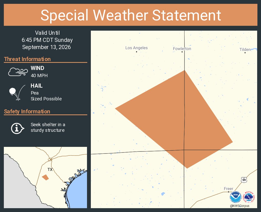
A special weather statement has been issued for La Salle County, TX until 6:45 PM CDT https://t.co/1kw9mnxsee
This graphic displays a special weather statement plotted on a map. The statement is in effect until 6:45 PM CDT.  The statement includes La Salle County, TX.  AN AREA OF STRONG THUNDERSTORMS WILL IMPACT SOUTHWESTERN MCMULLEN and SOUTHEASTERN LA SALLE AND NORTHWESTERN DUVAL COUNTIES UNTIL 645 PM CDT. The threats associated with this storm are wind gusts up to 40 MPH and pea sized hail. Seek shelter in a sturdy structure until the storm passes.
407 views · 1 likes · 0 reposts · 0 replies Open on X →
A special weather statement has been issued for Freer TX and Seven Sisters TX until 6:15 PM CDT https://t.co/b79EGMgAra
This graphic displays a special weather statement plotted on a map. The statement is in effect until 6:15 PM CDT.  The statement includes Freer TX and  Seven Sisters TX.  AN AREA OF STRONG THUNDERSTORMS WILL IMPACT SOUTH CENTRAL MCMULLEN AND NORTHWESTERN DUVAL COUNTIES UNTIL 615 PM CDT. The threats associated with this storm are wind gusts up to 40 MPH and pea sized hail. Seek shelter in a sturdy structure until the storm passes.
431 views · 2 likes · 1 reposts · 0 replies Open on X →
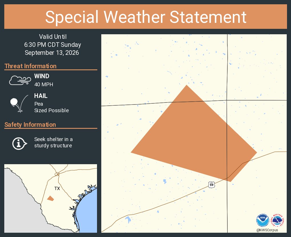
A special weather statement has been issued for Webb County, TX until 6:30 PM CDT https://t.co/NflSzBnbfr
This graphic displays a special weather statement plotted on a map. The statement is in effect until 6:30 PM CDT.  The statement includes Webb County, TX.  A STRONG THUNDERSTORM WILL IMPACT NORTHWESTERN DUVAL AND EAST CENTRAL WEBB COUNTIES UNTIL 630 PM CDT. The threats associated with this storm are wind gusts up to 40 MPH and pea sized hail. Seek shelter in a sturdy structure until the storm passes.
382 views · 0 likes · 1 reposts · 0 replies Open on X →
A special weather statement has been issued for Freer TX until 5:45 PM CDT https://t.co/kMk18murAa
This graphic displays a special weather statement plotted on a map. The statement is in effect until 5:45 PM CDT.  The statement includes Freer TX.  AN AREA OF STRONG THUNDERSTORMS WILL IMPACT NORTHERN DUVAL AND EAST CENTRAL WEBB COUNTIES UNTIL 545 PM CDT. The threats associated with this storm are wind gusts up to 40 MPH and pea sized hail. Seek shelter in a sturdy structure until the storm passes.
487 views · 2 likes · 3 reposts · 0 replies Open on X →

Against accounts of the same size

5 posts from the last 90 days, next to the 10K–100K follower range. below its peers on both reach and engagement.

Median views418this account924median for 10K–100K
Reach, %1.40%this account3.62%median for 10K–100K
Engagement, %0.26%this account1.52%median for 10K–100K
MetricThis accountMedian for 10K–100KRatio
Median views per post4189240.45×
Reach (views ÷ followers)1.40%3.62%0.39×
Engagement rate0.26%1.52%0.17×

Others in this range →   Compare with another account →   How these benchmarks are built →

Growth & engagement

How the posts we collected actually performed: views and reaction rate post by post, what the audience did with them, and where the follower count goes.

Views per post

48713 Sep
382
431
407
418

Last 5 collected posts, oldest on the left. The scale is logarithmic: one post can outrun the rest a hundred times over.

Engagement rate per post

1.03%13 Sep
0.26%
0.70%
0.25%
0.00%

Reactions — likes, reposts, replies and quotes — divided by views. Median for 10K–100K accounts is 1.52%.

What the audience does

Likes50.0%5 in total
Reposts50.0%5 in total

Share of every reaction we collected for this account. Replies mean argument, reposts mean endorsement, bookmarks mean the post was worth keeping.

The follower curve appears once this account has two daily snapshots — we take one a day, and this one is on its first.

Similar accounts